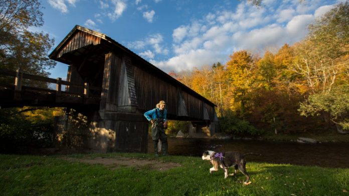
At one time, there were more than 300 covered bridges in NY state. Today, the Ulster and Sullivan county region boasts some of the most spectacular bridges left, most built in the 1800s.
Looking to rev up your seasonal leaf peeping a notch? One of the Hudson Valley’s best-kept secrets might be just the thing: Wooden covered bridges.
While these historical gems might inspire thoughts of New England, New York state is also home to these treasures. At one time, there were more than 300 covered bridges in the Empire State, but time, weather and progress have caused that number to dwindle to around a couple of dozen. Luckily, the Ulster and Sullivan county region boasts some of the most spectacular covered bridge sites around, most built in the 1800s.
Amazon: Historic Orange County house on warehouse site may find new home
Hudson Valley: Check out some local roadtrips for fall leaf peeping
Business: Kosher wine company looking at Goshen warehouse
First, a little history. Why covered bridges in the first place? The biggest reason was to protect the wooden structures from rain, snow, ice, moisture and sun, which would cause them to fail faster. Speaking of weather, in winter, it was common practice at the time to shovel snow into the bridges, so that horse sleighs could cross them without damaging the wood.
The fine craftsmanship of these bridges is a treat not to be missed – especially during the fall. So plan your route, and take a road trip to visit the historic covered bridges that dot our landscape. In today’s times of uncertainty and stress, they’ll charm you with notions of a simpler way of life from long ago.
While all these bridges are Instagram-worthy, some are located on private property, others require ticketed access, so adhere to all regulations when visiting.
Ulster County
It’s best to set aside a couple of days if you’re planning to visit all the covered bridges in Ulster, especially if you decide to make side trips along the way.
Ashokan Bridge
Ashokan Bridge (also known as the Turnwood Bridge or New Paltz Campus Bridge) is a wooden covered bridge over the Old Channel of the Esopus Creek. It’s located on the grounds of the Ashokan Center outdoor education, conference and retreat center in the Catskill Mountains of Ulster County.
It was built in 1885, and is a single span, gable roofed, covered timber bridge, measuring 72 feet, 6 inches long. The structure was originally located at Turnwood and moved to its present location in the 1930s. Ashokan Bridge was added to the National Register of Historic Places in 2000.
This is a private bridge, and an appointment is needed to visit. Go to ashokancenter.org, click on Day Passes to find available time slots for visiting the bridge. Fees to walk the grounds are: $10 per person, ages 18 and up; $5 per person, ages 12-17 years; free for kids under 12 years. The Ashokan Center is located at 477 Beaverkill Road, Olivebridge, 845- 657-833.
Did you know? Ashokan Bridge is located on the grounds of what is formerly the Ashokan Field Campus of the State University of New York at New Paltz.
Find it: Follow Route 213 through Olive Bridge to Route 28A. Turn right for 1.5 miles, then right on Beaverkill Road for 1 mile. Gate to the Ashokan Center will be on your right. There is an approximate .5 mile walk to the bridge.
Forge Covered Bridge
Forge Covered Bridge is a wooden covered bridge over Dry Brook, in the town of Hardenburgh in Ulster County, originally built in 1906. It has a single span of 27 feet. This is a private bridge with locked fencing over the entrance, maintained by the owner.
Did you know? There is a beautiful sight immediately downstream from the bridge, where swift running water has worn the sandstone bedrock into beautiful curves, deep cuts and various sized potholes.
Find it: Since this bridge is on private property, no trespassing is permitted; however, it can be observed from the road, as long as you keep a respectful distance and don’t trespass. It’s southeast of Arkville, off Dry Brook Road.
Mill Brook Covered Bridge
Mill Brook Covered Bridge (also known as the Grants Mills Covered Bridge) was originally constructed in 1902. It is over the Mill Brook, a single span of 66 feet. Owned and maintained by the Town of Hardenburgh, the structure carries pedestrian traffic. This bridge was rehabilitated in 1991 by one of the great-grandsons of the original builder. It was listed on the National Register of Historic Places in 1998.
Did you know? To help fund this bridge’s restoration, wooden pins used in the construction called treenails (pronounced “trunnels”) were sold to individuals with the stipulation that their names would be imprinted on them. When visiting the bridge, be sure to look for the many names written on the treenails.
Find it: The bridge at the intersection of Davis and Mill Brook roads in Margaretville. Note: While owned and maintained by the town Hardenburgh, which is in Ulster, the bridge’s address is in Margaretville, which is in Delaware County.
Perrine’s Covered Bridge
Perrine’s Covered Bridge, built in 1844, is pedestrian-only and located in Esopus-Rosendale, just a few hundred feet to the east of Interstate 87, crossing the Wallkill River. The bridge was named after James Perrine (1801-1860), son of French immigrant James W. Perrin and Huguenot descendant Catherine Freer, who operated a hotel/tavern at the site of the future bridge. The bridge made it easier for more than 1,000 workers to travel to work at the nearly 20 mills and factories nearby at the time. Perrine’s Bridge was added to the National Registry of Historic places in 1973.
Did you know? Perrine’s is New York’s second-oldest covered bridge.
Find it: The bridge is southwest of Rifton, off of Route 213.
Tappan Covered Bridge
Tappan Covered Bridge (also known as the Kittle Covered Bridge) was built in 1906. The only portion of the original bridge that remains is the framing; thus, it does not qualify for the National Register of Historic Places. It is over the Dry Brook, a single span of 43 feet, and is owned and maintained by the town of Hardenburgh.
Did you know? At one time, at least eight covered bridges stood over Dry Brook in Ulster County.
Find it: From Rt. 28 in Arkville, take Dry Brook Road for 8.5 miles.
Sullivan County
Given their proximity, these covered bridges can easily be visited in a day, if so desired.
Beaverkill Covered Bridge
Beaverkill Covered Bridge (also known as Conklin Bridge) is one of four covered bridges still standing in Sullivan County. It is owned by the Town of Rockland and maintained by the county, carrying traffic across the Beaver Kill. Built in 1865, this 98-foot-long, wooden single-span structure incorporates the lattice truss design perfected early in the 19th century.
The bridge runs through one of the oldest campgrounds in the area, Beaverkill State Campground. In 2007, it was listed on the State and National Registers of Historic Places.
Did you know? The Beaverkill Covered Bridge was an early step in bringing civilization to a remote area that had remained mostly unsettled well into the 19th century.
Find it: The bridge is located near the intersection of Ragin and Campsite roads.
Halls Mills
Halls Mills Covered Bridge, built in 1912, carries pedestrian traffic across the Neversink River on a 119-foot-long, clear span structure using the lattice design first patented in 1820. The bridge has six buttresses on each side and is one of five covered bridges in New York State that has a timber approach. The bridge was retired from vehicle use in 1963. It is not yet on the National Register of Historic Places.
Did you know? This bridge is considered the last remaining symbol of a community established by early settlers of the Upper Neversink Valley, led by Quaker preacher John Hall.
Find it: The bridge is located just south of Claryville in Sullivan County, on what’s called the Hunter Road Spur, off of Hunter Road. There’s a small parking area near the bridge.
Livingston Manor
Livingston Manor Covered Bridge/Van Tran Flat Bridge, formerly known as the Mott Flats Bridge, is the oldest of the Catskills’ lattice-style bridges, built in 1860. This bridge was closed for more than four decades, finally undergoing restoration in 1984. It spans 117 feet across the Willowemoc Creek, where visitors are welcome to fish. It is open to cars. The bridge is located off County Route 179 on Town Road 39, Covered Bridge Road.
Did you know? Located adjacent to the bridge is Livingston Manor Covered Bridge Park. The park is open daily May-Oct. from 8 a.m. to dusk. Even if the park is closed, the bridge remains open for traffic. Picnic areas, group picnic pavilion (fee) and portable toilet facilities available.
A short distance from the bridge is the Catskill Fly Fishing Center & Museum, 1031 Old Route 17, Livingston Manor; 845-439-4810.
Find it: The bridge is on Covered Bridge Road off Sullivan County Route 179. Route 17 can be seen from the bridge and the nearby Livingston Manor Covered Bridge Park.
Willowemoc
Willowemoc (also known as Bendo) Covered Bridge, originally built in 1860 in Livingston Manor, was cut in half and moved to its current Town of Rockland location, just outside of DeBruce, in 1913. It spans Willowemoc Creek on Conklin Hill Road, has a covered lattice through truss design, with a single span of 48 feet. It is owned and maintained by the county.
The Bendo Covered Bridge plays an integral role in the adjoining campground, the Covered Bridge Campsite, where it stands.
The bridge does not qualify for National Registry of Historic Places.
Did you know? In 1970, high waters on the Willowemoc Creek undermined one of the bridge’s abutments, dropping one end of the bridge into the creek below. After repair work, it was ready for limited local traffic. In 1985, the bridge was once again rebuilt, but this time without functional trusses, so it is now considered a “stringer,” or a more modern, less authentic covered bridge.
Find it: The bridge is at 74 Conklin Hill Road near Debruce in Sullivan County.
What about “stringers”?
A “stringer” is classified as an historic bridge, but is more modern or not as authentic, since the original truss no longer supports the bridge. Besides the Willowemoc (Bendo) Covered Bridge, other local stringers include the following:
Friendship Manor Covered Bridge (also known as Pine Hill Covered Bridge) in Ulster County, built in 1992, is located at the entrance to Catskill State Park. It is 72 feet long and spans the Birch Creek. The bridge is open to both vehicle and pedestrian traffic.
Find it: The Maurice D. Hinchey Catskills Visitor Center (CVC) at 5096 Route 28 in Mount Tremper is the official visitors’ center for Catskill State Park, where you can find maps, brochures, merchandise and other information on the bridge and other attractions. (845) 688-3369; visitthecatskills.com/catskill-park
Myers Covered Bridge (also known as Eagle Covered Bridge, New Covered Bridge, Drexel Covered Bridge) in Ulster County, built in 1990, is a modern bridge located in the Town of Hardenburgh, Ulster County. It’s a steel stringer bridge with a concrete deck and an added wooden cover with a simulated Kingpost Truss. It spans Dry Brook and is open to vehicle traffic.
Find it: The bridge is located on Dry Brook Road, Hardenburgh, south of Arkville, in Catskill State Park.
Chestnut Creek Covered Bridge (also known as Grahamsville Bridge), built in 1976 as a Bicentennial project at the entrance of Neversink Park, spans Chestnut Creek and is 40 feet in length. It is open to vehicle and pedestrian traffic.
Find it: The bridge is west of the village of Grahamsville on Route 55.
For more information on local covered bridges, including GPS coordinates, visit the New York State Covered Bridges Society at www.nycoveredbridges.org.
Fina Badalato is a Hudson Valley freelance writer. Contact her at thnewsroom@th-record.com
Credit: Source link


