My first opportunity to paddle on Jabe Pond was while I was doing some summer loon research, recording and observing loon behaviors. The pond was then, and is still, an interesting and rewarding paddle. The loons were quite cooperative. That summer I found their nesting site and observed them socializing, incubating their eggs, caring for their two chicks; teaching them to fish; to avoid predators; eventually fledge and fly south. At times fellow loons visited from Lake George (especially when the lake was well peopled). Over the duration of the summer I often saw ducks, osprey, deer, turtles, an occasional Bald Eagle and other wildlife. I even saw paw prints of a bear in the sand.
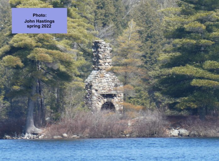
Although I am not a fisherman, I know that Jabe Pond is a popular trout fishing location. It is about 3 miles in circumference with an average depth of 30 feet and a maximum depth of 60 feet. There is one larger wooded island (no camping ) and a number of small rock islands. One of which has a large stone fireplace that once went with a cabin.
Typically I was not the only visitor. There were several visitors to Jabe Pond that summer. Many were fishermen; others were fellow paddlers out for a nice day on the water. There were some hikers and still others were taking advantage of the six or so camping sites around the pond. Almost every time I was on the water I passed an island with the ruins of a rather large stone fireplace. Eventually I learned that some called the island “Chimney Island,” Imagine that??? I always wondered about its history. Was it a hunting or fishing camp or a chapel? The YMCA Silver Bay Center is just down the mountain on the shore of Lake George.
This mystery has always been with me. So, last fall, after 20 years, I decided to try to solve it. I made inquiries through some friends; with the New York State Department of Environmental Conservation; and with local historians. One of my thoughts was to trace the Jabe family. Boy, was I in for a surprise ?? As I began looking at tax maps and deed records, and sought out the advice of the Hague Historian I found that there was no Jabe family. There was however a Patchin family and there had been a Jabez Patchin.
The Town of Hague historian, Sally Rypkema, has been a very great help with my inquiry about the Patchin family. A decade before the American Revolution when New York was still a colony of Great Britain, Samuel Adams (not THE Sam Adams of Boston ) applied for and received a land grant of 500 acres on the shores of Lake George from the British Crown. By 1867 Adams was living on his land grant, which was known as the Sabbathday Patent. (now known by its modern spelling as Sabbath Day Point) Adams was encouraged to build a house of entertainment ( really just a boarding house ) for the accommodation and convenience of travelers up and down Lake George.
Samuel Patchin, who served as a Captain in the Revolutionary War purchased the property from his cousin Samuel Adams and built a larger, log house on the site of the former Adams house for travelers, and continued operating the boarding house as Adams had done before him.
At this point Jabez Patchin enters the picture ( b. 1783 – d. 1847 or 1848 ) the first of Samuel’s sons. Jabez was far more interested in hunting and fishing, and farming than running a boarding house. He made his way to a nearby mountain pond and established a small farm. In about 1806 Jabez decided to descend the mountain, get married, and start a family. He built a cabin on the property that would later become the Silver Bay Association. He married Sally Garfield and they had 10 children. Sally died in 1839 and Jabez then took a second wife Lois Miller. They had an additional child, a daughter Frances. Jabez died in 1847 or 1848 at age 63.
The property eventually passed into the hands of a man named Seneca Prouty. There is today a private hiking trail that passes by the homestead of Jabez. The trail is maintained by the Silver Bay Association and permission MUST be obtained. These trails are NOT part of the DEC trail system.
 Topo map of Jabe Pond area showing trail from Silver Bay, access road, parking, and Chimney Island, primative camping sites. Map credit Rick Ro
In 1885 Seneca Prouty sold the property to Judge John Wilson who moved to expand the boarding house into a small hotel. In order to obtain a Post Office, Wilson gave the site the name Silver Bay. In 1897 Wilson sold the property to Silas H. Paine and his wife Mary Paine. The Paine’s and their friends acquired more adjacent property and in 1917 the Young Men’s Christian Association ( YMCA ) was centered at Silver Bay.
So, where did “Jabe” come from? I can well understand the pond being named after an early inhabitant. And “Jabez’s Pond ” might be a bit difficult to pronounce for ordinary language. But why Jabe Pond and not Jabe’s Pond?
But it didn’t get to be Jabe Pond without some detours. For many years Jabe Pond was called South Pond and appears as such in several Warren Co. maps. ( 1858 – Chase Atlas, 1871 – Adams & Asher Atlas, 1876 – Beers Atlas ). By the early 1900’s the pond appears as Patchen’s Pond ( 1889 – Seneca Ray Stoddard , Lake George Map: 1897, Stoddard, Lake George Map; 1911, Stoddard, Lake Champlain Map ) Note: the spelling was Patch(e)n’s Pond and not Patchin’s Pond. But by 1912 Stoddard referred to the pond as Jabe Pond perhaps in simple recognition of local usage?
 Two maps side by side: Asher & Adams map – 1871, South Pond – Mike Prescott collection and Stoddard map – 1889 Patchen Pond – John Hastings collection
This brings us back to the Chimney on Chimney Island. Was it a hunting / fishing camp or perhaps a chapel or something else ? The answer comes to us from E. Clark Worman, in his book The Silver Bay Story (1952), “Jabe Pond had always been a sort of fascination for the guests of Silver Bay and at various times has lured the management into schemes that never panned out. . . A special Jabe’s Pond Committee was appointed soon after the [ 1897 property ] purchase to see what best use could be made of this beautiful isolated area. It was recommended that a Jabe’s Pond fund be created by special contributions and that all building be owned by the corporation. Mr. S. Earl Taylor constructed a private camp on one of the islands in 1905 ‘away from the vestige of civilization.’ Tents were erected, the cost of $10.00 per week or $1.50 per day . . . After Mr. Taylor’s experience the Committee recommended that the island be developed first as an ideal private camp to accommodate about ten persons. It was hoped that Jabe’s Pond would be developed as a place of rest and recuperation for leaders in Christian work.“ Unfortunately the camp burned with-in a few years, probably in 1908.
The State of New York acquired the property in 1975 from the Silver Bay Association. Jabe Pond is in northeastern Warren County and it is part of the Lake George Wild Forest, maintained by the New York State Department of Conservation. The DEC Forester in charge is Rebecca Terry out of the DEC office in Warrensburg, NY.
NOTICE: The trails from Silver Bay are NOT public (DEC) trails. Permission must be obtained from the Silver Bay Association.
DIRECTIONS to Jabe Pond are from the Town of Hague 1.4 miles south on Rt 9N, turn right on Split Rock Road. After 1 mile Split Rock Road ends and becomes Battle Hill Road another .7 miles turn left off Battle Hill on to Jabe Pond Road. This is a seasonal, narrow dirt Road subject to washouts .9 miles to the parking lot. (The road is closed for spring and fall mud season and open in winter as a snowmobile trail ) There is a short carry from the parking lot to the pond. No motors are allowed on the pond. From the Town of Bolton (intersection of Riverbank Road and Rt 9N.) drive north 15.6 miles to Split Rock Road turn left and then follow the same directions as above.
Many thanks to Rick Rosen for mapping and computer graphics. Also thanks to Sally Rypkema, and John Hastings.
References Consulted:
Asher & Adams, New Topographical Atlas and Gazetteer of New York, Warren County. 1871 ( Collection of Mike Prescott ).
Beers, F. W. County Atlas of Warren New York, 1876, (collection of John Hastings ).
Billing, James F., Editor and Publisher, Central Southeastern Adirondacks New York Fishing Map Guide, Sportsman’s Connection. 2004.
Brown, Phil, Adirondack Paddling: 65 Great Flatwater Adventures, Second edition, 2019, Lost Pond Press, pages 110-113.
Chase, J., Map of Warren County New York, 1858 ( Collection of Mike Prescott ).
Department of Environmental Conservation, Warrensburg Office, Robert J. Bradley, Land Surveyor, Bureau of Real Property, email correspondence, January 2022.
Department of Environmental Conservation, Warrensburg Office, Rebecca Terry, DEC Foster, Lake George Wild Forest, email Sept / Oct 2022.
Delaware & Hudson Company / Lake George Steamboat Company, Lake George map, c. 1930’s.
Hastings, John, conversations, emails, and photographs, January- September 2022.
Helm, Gail, Silver Bay YMCA, ( former employee and materials and archives ), Email correspondence, January 2022.
Johnson, Mark C. Executive Director, Silver Bay Association: A Pictorial History 1900 -1935, Silver Bay Association, 1992.
Martucci, David, Town of Hague Assessors, Emails, Fall 2021.
New York State Forest Preserve. Map of Lake George , 1916, edited 1946, ( Collection of Mike Prescott).
Peterson, Amanda, Town of Hague, Clerk Assessor’s Office, email conversations, fall 2021.
Rypkema, Sally, Town of Hague Historian, conversations and emails 2021-2022.
Silver Bay Association, Silver Bay Association; A Pictorial History ( 1900 – 1935, Silver Bay Association, 1992.
Stoddard, Seneca Ray, Map of Lake George, 1889. (Collection of Dr. Dan Way).
Stoddard, Seneca Ray. Map of Lake George, 1897, (Collection of John Hastings ).
Stoddard, Seneca Ray, Map of the Adirondack Wilderness 1901, (Collection of John Hastings).
Stoddard, Seneca Ray, Map of Lake Champlain, 1911, (Collection of Dr. Dan Way ).
Stoddard, Seneca Ray, Map of the Adirondacks, 1912, (Collection of Mike Prescott).
Terry, Rebecca, DEC Forester. Warrensburg, email correspondence, fall 2022.
Warren County Records Storage, Deeds and Taxation office., spring 2022.
Worman, E. Clark, The Silver Bay Story ( 1902 – 1952, Silver Bay Association, 1952.
Maps –
– 1858 – South Pond – J. Chase
– 1871 – South Pond – Asher & Adams
– 1876 – South Pond – F. W. Beers
– 1901 – Stoddard Map – South Pond ( Mike Prescott )
– 1897 – Stoddard Map – Patchen Pond – ( John Hastings )
– 1889 – Stoddard Map – Patchen Pond – Lake George ( Dan Way )
– 1911 – Stoddard Map – Patchen Pond – Lake Champlain ( Dan Way )
– 1912 – Stoddard Map – Jabe Pond ( Mike Prescott )
– 1916 – (edited 1946) NY State Forest Preserve
Credit: Source link


