Most New Zealanders will travel the stretch of State Highway 1 between Taupō and Tūrangi sometime in their lives.
On one side, a high cliff often hugs the skyline as the road moves through small holiday townships and Māori marae. The largest lake in Australasia stretches out from the other.
At the highway’s northern end, there is the jostling signage of Taupō’s lakefront hotels and motels.
At the southern terminus, Tūrangi is a mix of raffish service-styles and up-market fishing lodges. The road crosses historic Ngāti Tūwharetoa lands and reveals the spectacular geology of the region.
There are tantalising glimpses of the snows of Tongariro, Ruapehu, and Ngauruhoe.
READ MORE:
* A guide to Tongariro National Park: When to go, where to stay and what to do
* Back Your Backyard: The natural gems of Taupō
* Wonderful things to see and do in the Waikato
* Palisade posts to reveal history in pā dating project
* New Zealand family travel: The treasures of Taupō
* Explosive lies: how volcanoes can lie about their age, and what it means for us
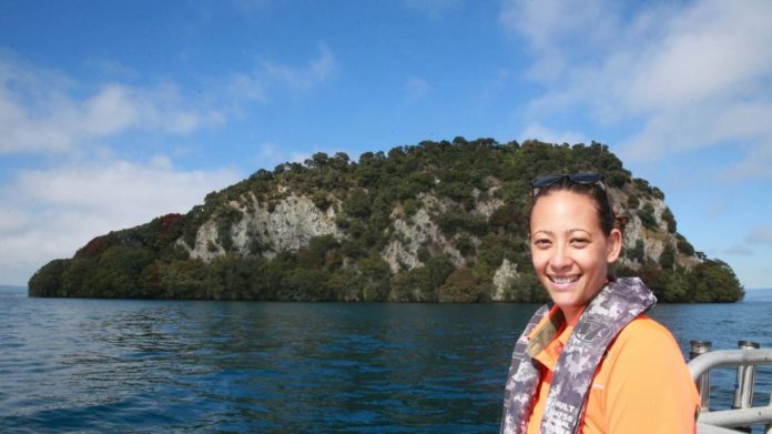
Lake Taupō’s only island, Motutaiko, lies mysteriously just offshore. It is the special responsibility of Candace Graham, who works as a community ranger for the Department of Conservation.
Of Ngāti Tūwharetoa descent, she was raised in Waitetoko, halfway between Taupō and Tūrangi.
MARK TAYLOR/Waikato Times
Motutaiko is Lake Taupō’s only island.
Motutaiko is a volcanic rhyolitic dome, abruptly rising up more than 100m vertically from the lake floor. Now under DOC protection, visitors are no longer permitted in order to protect its unique species and history.
“It is a wāhi tapu, a sacred place, and the reason for that is because it is the final resting place of some of my tīpuna, or ancestors,” says Graham.
“It was also an island refuge at some point for people in Motutere if they were under threat from an intruding war party, for both women and children… There are still some features from their time which are still present and undisturbed.”
Motutaiko is a urupā or cemetery. “Bodies were placed on the island and they weren’t buried, they were placed in caves,” says Graham.
“But over time they were being disturbed and their bones were being taken and the items they were buried with were also being taken. We have lost quite a few.
“In 2003, a decision was made to close those islands and leave them at rest to prevent them from being disturbed. Some caves were closed. You can’t even see where they are anymore.”
MARK TAYLOR/Waikato Times
Department of Conservation biodiversity supervisor Jo Mendonca, left, fishery ranger Tim Maule and community ranger Candace Graham recently visited Motutaiko to check on pest traps and the state of local fisheries.
The small island is also important for its unique species, ranging from mistletoe to skinks and snails, but they have recently come under threat from Norway rats.
“Up until 2018, when we discovered rats on the island, it had been pest-free. It is just far away enough from the mainland so that we believe that rats couldn’t have swum there. They pose a very real risk to the Wainuia snails and the skink. Rats may also be after the calcium in the bones of the tīpuna – so it is a double threat.
“I don’t think these species would have had a chance if DOC had not offered to lead this project – and getting those rats off the island,” Graham adds. “It is a really good collaborative effort.
“Collectively we all need to be advocating for the importance of the island and just staying off it – but you are more than welcome to come up and admire it from your boat.”
For Graham, Motutaiko also represents something profound.
“You feel the soul of the place, so it is highly, highly spiritual experience for me.
“From being on the water and being surrounded by waves – when you are on boat or kayak, and you come up to the island – its presence is quite unnerving. If you look at it from the shore, it doesn’t look like a huge place, but when you get right up to it, it is quite humbling.
“There is always a process I go through culturally to protect myself, and my team-mates, and the place, and my tīpuna. We always say a karakia – and you can usually always feel settled once that has been done. For me, it is huge recognising those feelings as I go through that process.”
MARK TAYLOR/Waikato Times
Visitors are no longer permitted on Motutaiko Island in order to protect its unique species and history.
Occupying the very heart of Aotearoa New Zealand, the whole Taupō landscape was created by an ancient, but still active super-volcano. Its crater, now filled with water, forms the lake
“We believe the last eruption happened in the austral late summer or early autumn of 232 AD, give or take five years,” says Professor Alan Hogg, the director of Waikato University’s Radiocarbon Dating Laboratory. His team’s research, year-dating trees felled by the violence of the final volcanic event, has been a revelation and settled a very long debate.
The time of the Hatepe eruption had originally been set at around 181 AD. This date is still repeated erroneously on innumerable Taupō tourist websites and in brochures.
It had been linked to historic records of red sunsets and other atmospheric phenomena observed by the Chinese and Romans. However, the work of Hogg and his colleagues pinpointed it with real accuracy for the first time.
The year was determined by the radio carbon dating of the tree-ring sequences of buried forests, including those at Pureora. The late-March/early-April season was indicated by fruits and seeds preserved beneath the ash falls. Even the very time of day was evidenced by insect assemblages in the preserved trees – so the huge climactic eruption probably occurred in the late afternoon.
Hogg’s colleague, Professor David Lowe, has produced a spectacular summary of this Hatape eruption. Over a period of time, there had been a series of gradually increasingly powerful volcanic incidents until a vent in the vicinity of the Horomatangi Reefs (now deep under eastern Lake Taupō) suddenly collapsed in upon itself.
MARK TAYLOR/Waikato Times
Candace Graham says visiting Motutaiko is highly, highly spiritual experience for her.
The resulting eruption column on that late summer day in 232 AD may have shot up 55 kilometres into the stratosphere. Around 120 cubic kilometres of material was ejected in total, a quarter of that in a very few minutes.
But even more devastatingly, a flow of hot gas and lava moved away from the eruption centre at speeds up to 900 kilometres an hour to blanket the central North Island in fewer than 10 to 15 minutes. It smoothed out valleys, mantled ridges, blocked rivers and streams, and destroyed all life from Waiouru to Rotorua under metres of material. Only Mount Ruapehu was high enough to divert the onrush of the super-heated wave.
Even this wasn’t the end. The lake refilled over time, but its outflow was blocked. Waters banked up more than 30m above present levels.
“The gigantic post eruption flood,” says Hogg, “resulted from collapse of a dam on the Waikato river outlet built by eruptive material.”
It was an instantaneous breach, 20 to 30 years after the Hatepe eruption. Water levels overtopped and broke a natural barrier of pumice and other material. A huge wave of containing around 20 cubic kilometres of water surged downriver in one abrupt release.
“This flood event has been estimated to have been one of the largest in the world,” states Hogg. The evidence can still be seen in landforms as far as 232 km down the Waikato.
MARK TAYLOR/Waikato Times
Waitahanui Lodge’s walls are filled with images of fishing adventures past.
The modern road between Taupō and Tūrangi follows the line of the southern volcanic crater rim-wall. Now flanked by holiday homes and businesses, this stretch of black tarseal gives travellers access to the shore and its recreational activities – and what has become the unique Taupō tourist experience.
“It’s all about keeping it real,” says Bron Bell of Waitahanui Lodge, describing the accommodation and access that they are determined to offer their motel guests. “If you want the Ritz, go to town.”
Located just a few hundred metres south of the Watahunui Stream, where anglers cast and recast their lines, the motel that Bell and her husband Anthony manage is unique. With a distinctive mid-20th Century New Zealand holiday architecture and its enviable shore-side location, Bell describes people who rebook a year in advance.
Two of the five self-contained cottages are thought to be the closest available rental rooms to the lake itself. There is nowhere else in Taupō where a guest can see and hear the lap of waves less than 3m away – without getting out of bed.
“They are authentic Kiwiana baches – with a modern twist,” Bell adds. The neatly painted pale white-and- blue cottages could easily illustrate a book on distinctive New Zealand holiday rental accommodation. While the Bells see continual improvements as being a necessity, the maintenance of the lodge’s unique character is essential.
MARK TAYLOR/Waikato Times
Anthony and Bron Bell are the managers of Waitahanui Lodge.
Waitahanui Lodge was originally founded in 1932 and catered to many famous trout fishermen. The American author of Western novels, Zane Grey, had publicised Taupō as a trout fisherman’s paradise with his 1926 book, An Angler’s El Dorado. Many of the Lodge’s guests in the 1930s and 1940s were drawn by his stories of limitless catches and battling large fish in the near-by pools on the Waitahanui Stream.
The Lodge moved location a few hundred metres in 1955 and now, facing north, the present buildings offer premier views, and a range of facilities from trout smokers to a small shop selling trout flies and espresso coffee. For Bell, there is another bonus – “We’ve got the most incredible sunsets you’ll ever see.”
Perhaps no city or region truly exists until it has been explored in fiction, like James Joyce’s Dublin in his book, Ulysses. Tina Shaw’s The Children’s Pond, is the first New Zealand novel to be set in Tūrangi’s motels, shopping-centre and the famous trout-pools of the near-by Tongariro River.
Formerly Shaw and her husband, Bruce, lived in Auckland, often travelling down to Tūrangi to fly-fish. Then they made the decision to move to Taupō permanently. For Shaw, Tūrangi is not simply a stage-setting.
“We often fished the Tongariro River. It is just gorgeous – it is so beautiful. And I was taken by the image of the divided town – you’ve got two sides to the town. You’ve got the river and quite a lot of wealth on one side of the highway and on the other side of the highway you’ve got this old hydro town which has got a few issues. “
“It seemed to me to be a divided location and for a fiction writer it is interesting to explore.”
MARK TAYLOR/Waikato Times
Tina Shaw’s The Children’s Pond is believed to be the first New Zealand novel to be set in Tūrangi’s motels, shopping-centre and the famous trout-pools of the near-by Tongariro River.
The Children’s Pond was the result. At times, it is a novel of nail-biting suspense and revelation, as the layers are gradually stripped away from the characters’ lives and their interactions. It also reveals an archetypal New Zealand location in a new light.
“Really, it is about a woman who moves from Auckland to Tūrangi to be near her son who is in Rangipo Prison. Through circumstances, she is forced to confront her past. It is a crime story – a psychological crime story.”
As could be expected, fly fishing plays a part in The Children’s Pond ,but so does the State Highway and the décor of Tūrangi’s motels. Shaw’s fictional The Lodge is a thin-walled strictly temporary construction. It has obligatory local references in its beige and mustard décor – and the paintings of river scenes and trout. Its cottages are named after fishing-flies.
“I think I’m really proud of capturing that location. I feel I pulled off that thing where you use a location and its character… I also really feel the river has got a bit of a presence in that novel.”
The road between Taupō and Tūrangi is often travelled, no matter the season, but when Covid-19 has closed New Zealand’s borders, it will be more travelled than ever before.
There will always been unseen things, and others to be discovered. There is always more beneath the surface.
Credit: Source link


