Chris Dillon has no worries drinking his whiskey with a splash of water from the Mataura River.
The river is the largest in Southland and people who live alongside it rely on it for tourism, agriculture, industry and recreation.
It is fair to say the water is not crystal clear top to bottom and while most of the river is tranquil, it became a scary force during the February 2020 floods when a Civil Defence emergency was declared.
The headwaters are in the Eyre Mountains to the south of Lake Wakatipu. From the Mataura Saddle in the mountains, it reaches the sea at the end of a 242-kilometre journey.
READ MORE:
* Water takes on the upper Mataura River are over-allocated
* Angling group seeks funds to fight rafting consent on Southland rivers
* Southland District mayor says ‘no’ gas leaks from paper mill in Mataura
The Waikaia River is the main tributary and joins the Mataura east of Riversdale, contributing half of all water flow into the catchment.
There are an estimated 181 farms on the Mataura River, according to Valuation NZ; 79 dairy, 95 sheep and beef, two deer and four arable.
About 30 farms have consents to take water from it.
Kavinda Herath/Stuff
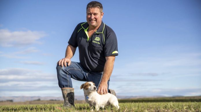
Ardlussa farmer and Southland Federated Farmers president Chris Dillon’s family has farmed next to the Mataura River for three generations in 100 years. He is pictured with his dog Bree. [File photo]
South of Cattle Flat, as the river reaches the Southland plains, and farmer Dillon has watched the river for years.
He gestures where the river will forge its next braid, which gravel islands will grow, which will be subsumed and which he will dig out.
“Nature is a powerful beast,” he says, before plunging his hands into the crystal-like water.
The Dillon’s Ardlussa farm is on both sides of the awa. The Dillons maintain the banks and paddocks so at least a hundred people a year can come and make use of the clear water.
Holidaymakers sometimes bring lawnmowers to help. Dillon is planting, mowing and levelling so the riverside is as welcoming as possible.
“It’s important to us because a lot of the time you’re busy farming, and you can’t get away from the farm, but you can get away to the river for an hour.”
Dillon has no problem putting the river water in his whiskey.
Dillon’s family have had the farm for 100 years. Dairy effluent would have flowed straight from an old shed into a waterway in generations past, he said.
Now, Dillon points out his fences are further from waterways than they need to be, and says he is not buying nitrate fertiliser for it to end up in the river; it is all monitored, and it all stays on the paddock.
The farm draws water from an aquifer and for Dillon the river represents a retreat.
He has memories of riding ponies on the banks as a youngster, and laughs at how summertime campers hit golf balls in a nearby field.
About 17kms downstream from the Dillon farm, to the south-east, the Mataura joins the Waikaia River. It then meanders next to State Highway 94 towards Gore.
Kavinda Herath/Stuff
Southland Fish and Game manager Zane Moss casts a fly into the upper Mataura River. [File photo]
Before the Covid-19 pandemic closed borders, anglers from Australia, the UK and the United States injected about $1-$2 million into Southland’s economy, as the river is renowned for its brown trout fishing.
Fish & Game manager Zane Moss has spent years fishing the river. Many spots are easy to wade across, and with plenty of access the abundance of brown trout are easy to see in the picturesque surroundings, he says.
Kavinda Herath/Stuff
Hokonui Rūnanga environment lead Riki Parata sits beside the river near the township of Mataura.
Confluence of industry and culture
Riki Parata (Kāi Tahu, Kāti Māmoe, Waitaha, Te Atiawa ki Whakarongotai) grew up in Gore and is the Hokouni Rūnanga environmental lead.
Parata grew up beside the river and recalls floating downstream on tubes, trout fishing, eeling and collecting kanakana (lamprey).
“Jeez, that was only 30-odd years ago. And seeing the dramatic change in it since then is quite astounding.”
The river used to be quite healthy, now those species he saw as a child are hard to find.
The Rūnanga had seen tuna returning since Rewai Anglem put in the river’s first fresh water mātaitai in 2006.
In the 30 years Parata has been keeping an eye on the awa, damage has been done by industry, communities and agriculture.
“It has been caused by people, and…it’s really up to people to get it back to the state where it once was.”
Alliance and the Mataura Industrial Estate have been helpful and cooperative with trap-and-transfers, tuna and kunakuna monitoring, and cultural health assessments on the river, Parata says.
He wants all industries to reduce their environmental footprint.
Ngāi Tahu mātauranga (knowledge)
The Mātaura awa is a statutory acknowledgement area for Ngāi Tahu, which holds it in high regard for cultural value.
The awa was a migrational trail, to the coast and towards Wānaka and Whakatipu.
Kanakana sustained Ngāi Tahu for centuries, and they came from as far as Kaiapoi and Christchurch during harvest season for the “hugely significant food source,” Parata said.
Comparing that history, with the diminishing health of the river over his lifetime, leaves Parata crestfallen.
“It’s very, very sad and … it’s very, very gutting that we’re losing something that has such cultural and spiritual and significant value to our people,” Parata said.
Routine long term water quality and freshwater ecology monitoring in the river began in the early-to-mid 1990s.
For a time the river was a dumping ground, Parata said, but “nowadays, luckily, that’s frowned upon, especially to iwi. We take a hard stance on discharges to the river.”
Supplied
The Mataura River catchment is 5400 square kilometres. [Environment Southland]
Contamination
Former Environment Southland science manager Elaine Moriarty says the largest contributor of contamination to the Mataura River comes from indirect agricultural contributions such as overland flow.
The highest concentrations of nutrients come from intensively farmed areas like Oteramika Stream, the Waimea Stream and its tributaries the Sandstone and Longridge, that are “all below the national bottom line for nitrate toxicity.”
There are also several direct discharges to the river from wastewater treatment plants and industrial discharges.
The large number of bugs and insects thriving in the mountains and hills of the upper Mataura and Waikaia catchments signify the good ecological health of the waterway, Moriarty says.
Robyn Edie/Stuff
The floodwaters of the Mataura River carried Garry Mulqueen’s 12.1-metre shipping container about one-and-a-half kilometres in February 2020 and wrapped it around a tree.
Below the Pyramid Bridge (about five kilometres east of Riversdale), the bugs and insects are in fair condition, coping with moderate organic pollution, she says.
Further down, bug and insect monitoring suggested the Waimea and Oteramika tributaries are in poor ecological health, with pollution and excessive nutrients like nitrogen and phosphorus.
The loss of forests, wetland drainage, river and stream habitat modification and extensive pastoral development, followed by intensification into arable crops and more recently increased dairying in the 1990s and 2000s, plus water abstraction, have all strongly influenced the water quality and ecosystem.
Many swimming sites are considered unsuitable because of microbial contamination, which is measured by monitoring E. coli levels, Moriarty says.
The only swimming places the council considered suitable are upper catchment streams like Piano Flat and the upper Mimihau.
Alliance’s Mataura meat works can discharge up to 8000 cubic meters a day of refrigeration cooling water, treated wastewater and the plant can also a dam, divert and discharge for a small hydro-electric scheme, which provides some renewable energy for the plant.
Alliance Group manufacturing general manager Willie Wiese says the ultimate goal for the Mataura plant is to improve operational performance.
Another goal is to reduce its impact on the environment and maintain the employment of the 500 people who work at the site, and continue to support the livelihoods of many others in the Southland region, Wiese says.
Robyn Edie/Stuff
Sand bags lined Salford St, Gore, as the river’s floodbanks started to breach during a Civil Defence emergency in Southland in February 2020.
A $4 million wastewater disinfection plant should be installed by 2024, which would significantly reduce E. coli, he said.
The co-op is also working on a biological treatment system, which would halve the amount of nitrogen discharged.
“Alliance is a large and diverse organisation so is respectful of all cultures and beliefs. Understanding and providing for Te Ao Māori is important to us, which is why we work closely with Hokonui Rūnanga.”
It normally takes 80 hours for water to flow from its origin near Lake Wakatipu to the sea at Fortrose. It’s 60 hours in a flood, Moriarty says.
Supplied
A discharge into the Mataura River in 2019. Environment Southland chose not to prosecute the Gore District Council for the discharge of toxic algae. Analysis identified that cyanobacteria was already present in the river at the time and the results did not breach World Health Organisation drinking water standards, the Ministry for the Environment and Ministry of Health guidelines for bio volume or consent contaminants limits.
When in flood the river can have a devastating impact, so much so there are five stopbank schemes.
Five major stopbank schemes have been carried out in the Mataura Catchment: in 1913, 1962 to 1964, 1970, 1973 and 1982.
There are 128 stop banks, totalling 107km, on the Mataura and its six tributaries. That includes 66km on the Mataura itself.
Supplied
The Mataura River catchment and testing locations, picture from Land Air Water Aotearoa.
Environment Southland catchment operations manager Ramon Strong said investment in flood protection essentially stopped with the loss of central government investment in the late 1980s and early 1990s.
But after the February 2020 flood, banks at Gore, Mataura and Wyndham would now be strengthened.
Near Fortrose, Paul King has been whitebaiting the river annually for 30 years.
The 60-year-old’s grandparents took him whitebaiting when he was child. King regularly casts a net with his 80-year-old mother, and his own son and grandson are “mad keen” on it as well.
King loves being in the great outdoors, and from his stand watches trout circling the smelt, fantails flying and the occasional seal.
“The wildlife is just magic to see.
“It’s nice and peaceful down here.”
King has noticed the river banks eroding and being sculpted by floods during the decades.
The water quality has remained much the same to King’s eye over the years, and even on days when there is a bit of scum on top of the water he still fishes.
“You have your good [whitebait] seasons and your bad seasons. It just varies over time.”
Kavinda Herath/Stuff
An aerial view of the river as it passes along the Mataura township.
Water quality has much to do with the rain, King says, as the waters at the end of the Mataura are flushed out by the tides.
“The quality of the water is still pretty good.”
King feels his grandson will have many years to enjoy the waterway, believing Environment Southland’s work in limiting phosphates entering the river to be a good step in protecting in.
Riparian planting, fencing waterways and farm environmental plans are examples of things Southlanders have done to improve the river’s health, Moriarty says.
However, more needs to be done to meet the guidelines of the National Policy Statement for Freshwater Management, she says.
The statement gives local authorities direction on how they should manage freshwater under the Resource Management Act 1991.
Potentially different land uses and stocking rates are “tools” that may be used to close the gap between where Southland’s environment is currently and where our community and government want us to be, she says.
Changes to the proposed Southland Water and Land Plan, which will be notified and consulted on by the end of 2023, is part of that work.
“We don’t have all the answers yet, but we know where to start, by improving the way we farm and cutting pollution from our businesses and homes,” Moriarty says.
“Working together, we can find practical solutions, take advantage of new innovations, and move step-by-step to improve our environment for future generations.”
Credit: Source link


