People enjoy hiking, skiing, running, camping, fishing, hunting, boating, and other outdoor adventures. These remote locations are often out of range of any cellular service, so your smartphone then turns into a camera that is only useful to capture your adventures. If you get into trouble and want to contact someone or share your location, then you need something better and maybe even something that extends the capability of your smartphone.
Garmin offers various satellite communication devices for your off-the-grid adventure, and the newest addition is the Garmin inReach Mini 2.
The inReach Mini 2 is an ultra-compact satellite communicator, available now for $399.99. We used it over the past couple of months to share our location and text family members while out of range of cellular towers during mountain hikes and river fishing. Thankfully, we did not have to make contact for an emergency situation, but it was great to know we had a capable device in hand in case of an unfortunate incident.
Like
- Small, rugged design
- Extensive satellite coverage
- Broad selection of subscription options
- Messaging and plotting support via smartphone
- Long battery life
Don’t Like
- Setup and familiarization take time
- Smartphone needed for text input
Specifications
| Display | 23×23 mm, 176 x 176 pixel resolution, sunlight-visible, monochrome, transflective memory-in-pixel |
|---|---|
| Water resistance | IPX7 |
| Connectivity | Iridium satellite services, Bluetooth, ANT+, GPS/GLONASS/GALILEO/QZSS |
| Battery | Rated for 14 days at 10-minute tracking and full-sky view down to two days with moderate tree cover and high detail activity tracking |
| Dimensions | 99.0 x 51.7 x 26.1 mm and 100 grams |
The original inReach Mini was released in 2018, and at first glance, it doesn’t look like much has changed. However, a significant improvement in battery life is the foundation of the inReach Mini 2. Garmin states that up to 14 days of run time with 10-minute tracking is available in the Mini 2, while 30-minute tracking extends battery life up to 30 days. If you charge it up, pack it away in a car, boat, or RV and then need to turn it on for an emergency, the device should power up while still within one year of charging.
Also: Best sports watch: Garmin, Coros, Polar, and more
Hardware
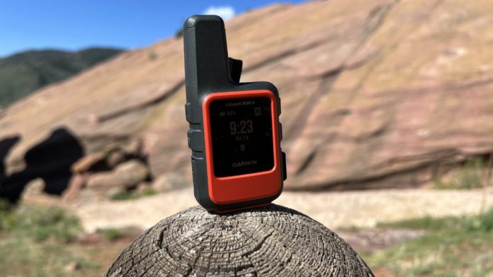
In addition to extended battery life, Garmin updated the design with a move from microUSB to USB-C for charging, which is an excellent choice as most mobile technology is moving to USB-C for charging. It still measures just four inches tall by two inches wide and weighs in at just 3.5 oz (100 g), so you can easily pack it along on any outdoor adventure. It is rated for IPX7 too so you won’t have to worry about using it out in any weather condition.
The Garmin inReach Mini 2 looks like a small walkie-talkie with an extended antenna that protrudes prominently from the top left corner. The antenna, top, both sides, and some of the bottom are covered in dark gray matte finish silicone that makes it very easy to hold onto while also offering some protection from drops.
The Flame Red color is also found in a silicone bottom panel. I was sent a Flame Red (more of an orange) color, but you can also purchase it in Black. The Flame Red makes a lot of sense for a safety device where you want to be able to easily see the inReach Mini 2 while out wandering the wilderness. It also is helpful to have this bright color if you drop it and need to find it. The Flame Red color is a durable hard plastic material.
The 23 x 23 mm monochrome display is found on the front of the inReach Mini 2 with a large bezel below it. It is not a touchscreen display, so all functions are controlled with buttons.
Up and down movement buttons are found on the left side with a tightly sealed cover protecting the USB-C connection port. The power button is on the top with a lanyard opening to the right of the power button. OK/select and back buttons are found on the upper right side.
There is a prominent SOS button on the lower right side, and it is designed so that you cannot accidentally press it and initiate an SOS response. It is clearly labeled with a rigid Flame Red cover topped by the silicone material. You have to position a fingernail under the cover and open it up to reveal the SOS button. Once you have it open, you simply hold it down to initiate an SOS signal until an alert sounds.
Centered on the upper back is a fabric loop that is secured to an opening with an Allen wrench. A carabiner is included in the package, so you can attach it to this loop and then to your backpack, jacket, or other gear for quick access and safe mounting. Other mounts, a dive case, and lanyards are available for purchase from Garmin.
Communicator software
After unboxing the inReach Mini 2, press the power button to turn it on. A default home screen appears, showing the battery status, time, and date. A three-line menu icon appears in the upper right corner that indicates you should press in on the upper right OK/select button to navigate the communicator.
After setting up a satellite subscription (see the options below), the menu will show options to send a message, write preset messages, start tracking, navigate, mark waypoint, show contacts, view your satellite service plan, or access the settings.
Settings include:
- Specifying options for tracking (time interval)
- sounds
- map (waypoint options)
- phone (pair and setup)
- inReach remote
- system.
System settings include:
- Backlight level
- compass calibration
- time
- units
- GPS
- language
- owner info
- screenshots
- and more.
Starting back from the main display, you can press the up or down navigation button to scroll through widgets loaded on the inReach Mini 2. This functionality is similar to scrolling through the glances on Garmin GPS sports watches.
These widgets/glances include messages, tracking status, navigation widget, weather widget, and message check. When one of these is highlighted, the OK/select button opens up another display with more information.
Two-way messaging is supported right from the inReach Mini 2, but there is no keyboard or voice-to-text option on the device itself. Thus, outgoing messages are limited to preset messages that you set up in advance of your adventure. Full text messaging is supported through a connected smartphone, discussed in the following section.
While the display is small, it is very readable in various lighting conditions and the compass, navigation tracking, messaging, and weather data are all useful when presented on the display.
Also: Epix (2nd Gen) review: Garmin’s best modern GPS sports watch
Smartphone software
The Garmin inReach Mini 2 connects to your smartphone through the Garmin Explore app, so you can text using the smartphone keyboard with the inReach Mini 2 as your satellite connection. The Garmin Explore app is also used to download maps, plan your trips, and connect to compatible Garmin watches, in-vehicle navigators, aviation systems, and more. It acts in a similar fashion to the Garmin Connect app that is used to connect your watches and other Garmin gear. The inReach Mini 2 does not connect to the Garmin Connect app.
After installing the Garmin Explore app, the first thing to do is to sign in or set up an account. You then connect the inReach Mini 2 so that you can check for software updates and manage sync settings. There have been a couple of software updates since I started testing out the inReach Mini 2, so to make sure everything continues to function as intended, you should check for updates before heading outside.
Display options in Garmin Explore include map, library, messages, devices, and account. TopoActive maps are available, and you can even download them to your phone prior to beginning your activity. Map control options are visible in the map settings too so take the time to set up the map how you need to see it in the field.
The library contains your activities, waypoints, routes, courses, and tracks. Routes, courses, and more are established.
The message display shows our incoming and outgoing messages. When you are out on an adventure and want to send a more complicated text than the default messages, you will use this display to send text messages entered on your smartphone via a satellite connection.
Other compatible Garmin handhelds and wearables can remotely control the inReach Mini 2 to send and receive messages, start and stop tracking, and trigger an interactive SOS. Airplane pilots can also use the Garmin Pilot app to send and receive text messages via the inReach Mini 2 satellite connection.
Website
The Garmin Explore website is also a key component of the inReach Mini 2 experience. My one con with the inReach Mini 2 is the rather extensive setup process to get all of the pieces together before starting your adventure. You cannot just charge it up and go to have a very full experience, so you need to use the device, phone, and website to get things lined up before hitting the trail.
After logging into your account, the Garmin Explore website is where you will view your inReach Mini 2 stats, view maps, manage your satellite subscription plan, and more. One key function of the website is to plan out your trip by creating routes and waypoints in the map view and then having them sync to the Garmin Explore app and then sync to your inReach Mini 2.
There is an inbox page where you can view all of the text messages that you sent and received from the inReach Mini 2. Your default preset and quick text messages are also created and managed here. You can have up to three messages set as preset messages for the inReach Mini 2. I have messages that state I am starting my trip, I am delayed and OK, and pick me up here. Up to 20 quick text messages can be set up on the Garmin Explore website. There are no charges for sending a preset message, but replies are charged. Outgoing and incoming quick text messages are billed.
In order for family, friends, and even social media followers to track your progress on a trip, you can set up a MapShare website. Email, Facebook, and Twitter accounts can be connected to share your MapShare site with people. I have mine set up to share with all of my immediate family and then adjust it for friends that may be around when I am headed out for an off-the-grid adventure.
I tracked one hike with a Garmin Epix and the inReach Mini 2, and while both tracked the exact same location at the set inReach Mini 2 interval, the 10-minute interval plot showed the obvious limitation of a 10-minute interval compared to a constant track. However, in the event of an emergency, you will likely be in the same position for a long period of time, so the progress of your trip is not as important.
You can also manage your account on the website, and these settings include your detailed contact info and emergency contacts, billing info, subscription status, SOS insurance coverage stats, and SMS message configuration settings (what details to include when you send out a message).
Also: Garmin Forerunner 945 LTE review: Connected features for safety and live tracking
Satellite subscription plans
| Safety | Recreation | Expedition | |
| SOS | Unlimited | Unlimited | Unlimited |
| Text Messages (*160 characters) | 10 | 40 | Unlimited |
| Preset messages | Unlimited | Unlimited | Unlimited |
| Tracking intervals | 10min+ | 10min+ | 2min+ |
| Send/Track points | $0.10 ea | Unlimited | Unlimited |
| Location requests | $0.10 ea | Unlimited | Unlimited |
| Basic weather | 1 text message ea | 1 text message ea | Unlimited |
| Premium weather | $1.00 ea | $1.00 ea | $1.00 ea |
| Premium marine weather | $1.00 ea | $1.00 ea | $1.00 ea |
| Annual plans | $11.95/mo | $24.95/mo | $49.95/mo |
| Freedom plans | $14.95/mo | $34.95/mo | $64.95/mo |
| Message overage charges | $0.50 | $0.50 | N/A |
The satellite connectivity requires a subscription with monthly and annual options available for three levels of usage. The global Iridium satellite network provides services. The lowest price plan is an annual plan with an $11.95 monthly fee and a month-to-month option (called Freedom plans) for $14.95 per month, while the most expensive monthly fee for an annual plan is $49.95 or $64.95 for the Freedom option. There is also a $34.95 annual fee for a Freedom Plan, even if you only activate one month of service, so make sure to look at the full year to see which plan is best for you.
The annual plan has a $29.95 activation fee with slightly lower monthly fees and the requirement for one year of service. The plans vary by the number of text messages included, tracking interval period, location requests, and weather. Unlimited preset messages and unlimited SOS messages are included in all of the plans. Premium weather and premium marine weather are $1 each with every plan too. Overage charges for the two plans with limited text messages are 50 cents a message.
SOS is available for unlimited usage with all subscription plans and will send a distress signal to the Garmin International Emergency Response Coordination Center, which is staffed 24/7 to assist you in the event of an emergency. You can purchase up to $100,000 coverage for additional search and rescue expenses for just $29.95 per year through the Garmin Explore website.
Connecting to emergency services is important, but you can also use the Garmin inReach Mini 2 to connect to family and friends to check in from your adventure or share your experiences as they happen. You can share your location with friends and even receive messages of encouragement while out in the wild. If you become lost on your adventure, the inReach Mini 2 can help you guide you back to your origin with its TracBack feature.
Daily usage experiences and conclusions
While I don’t get out for trail running as much as I would like, my cell phone doesn’t connect to any towers when I am out there in the Cascade mountain range. I spend quite a bit of time fly fishing on various rivers, and my wife worries that I may someday fall in the river and be lost down the rapids.
The Garmin inReach Mini 2 is a perfect companion for these kinds of scenarios when I want to help a family member know that I am OK and even give them the opportunity to track my progress through the wilderness. While Garmin has an assortment of devices available, the inReach Mini 2 is the right size and price for me.
I am also satisfied with the available subscription options where the basic essential option is about the price of one lunch yet provides that safety net in case of an emergency. Even if you are not in an emergency but running later than expected, you can use the inReach Mini 2 to ease the worry of family and friends.
The battery life is solid for a device that is so small, and the GPS has proven to be accurate. The display is very readable, and the connectivity support to a smartphone is extremely useful. For longer adventures, you should probably consider a large portable battery pack or a solar battery pack to keep your phone charged up for the extended experience.
The USCG motto is Semper Paratus, always ready, and with the Garmin inReach Mini 2, I can live up to that motto and put people at ease knowing I am out exploring this beautiful country with a small device watching my back. It is actually a pretty freeing experience knowing that I can go on an adventure, and if something bad does happen, I can make sure people know and at least are on the way to help me out.
I may still have to use some of my survival skills, but it helps to know that people at least know you are in trouble and need assistance.
Latest review
Credit: Source link


