For more stories like this, check out The Chronicle’s weekly Travel newsletter! Sign up here.
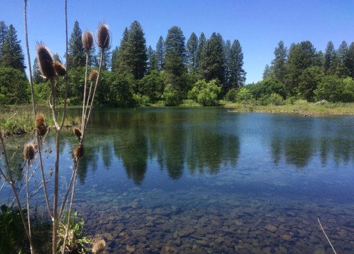
Just a few paddle strokes gets you into California’s only exclusive boat-in state park, a matrix of natural lakes and streams fed by underground volcanic springs in the state’s far north.
Ahjumawi Lava Springs State Park is located in remote northeastern Shasta County near McArthur in the Fall River Valley. Those who know the park simply call it “Ahjumawi.” In the native language of the Pit River Tribe it means “where the waters come together.”
There is no better place in Northern California that puts together kayaking and canoeing, small power boats, camping (first-come, first-served), bird watching, trout fishing and history. Launch for free from a primitive boat ramp into miles of flat-calm waterways, views of Mount Shasta and Lassen Peak, and a symphony of calls from migratory songbirds.
Unlike the state’s reservoirs, the lakes here are always full. Hidden surprises include a series of tribal stone fish traps.
Though many visitors may be wary about drifting smoke from the north state’s wildfires, by Monday it was pristine at dawn, hazy by late afternoon. The hot afternoons, expected to hit the 100s again this weekend, are the bigger concern. To cool off, paddle to the edge of a spring-fed channel and enjoy the crystal-pure waters that flow throughout the park.
Getting there
Nobody ventures to Ahjumawi by accident. It’s a long drive for most — roughly 300 miles from San Francisco — and you need a boat to access it. Come prepared to camp ($15 per night) and rely solely on yourself.
The heart of the Fall River Valley is a web of connected waterways, where Fall River, Tule River, Ja-She Creek, all spring-fed, flatwater streams, are connected to Big Lake and Horr Pond. The surrounding landscape is oak woodlands edged by endless water, a primary habitat for migratory songbirds, shorebirds and bald eagles.
Many shallow areas are off limits to larger powerboats. In addition, the drive to the boat ramp passes over several narrow cattle guards, where larger trailers can catch a wheel, ripping off your trailer axle. (It has happened at least a half dozen times, according to a local auto shop.)
A canoer makes land at Ahjumawi Lava Springs State Park in Shasta County.
Tom Stienstra
In the town of McArthur, you turn left on Main Street and drive about a half-mile out of town (the road turns to gravel) to a fork. Take the right fork onto Rat Farm Road, drive over a canal, and continue 3 miles to the end of the road to a parking area and a hard-packed dirt boat ramp called “Rat Farm.” There’s no dock, just a chemical toilet and an information billboard.
Note: If using Google Maps, use “Rat Farm, McArthur.” Do not use the directions to Ahjumawi — they are incorrect and will guide you to a gated road that has been closed for years.
Load your boat with supplies at the ramp then push off from shore and away you go. As with most state parks, no dogs are allowed.
From the boat ramp, you head out through a channel adjoined by marshlands a few hundred yards to the primary waterway. You should then turn left (west). As you propel ahead, you’ll pass a shoreline, where the land on your right then curves in a half moon and to a series of smaller points and coves.
On your right is Horr Pond Campground, named for rancher Henry Horr who, with his wife, Ivy, owned 6,000 acres here in the 1940s. There is a boat ramp here and beyond the second point in the next deep cove is Crystal Springs Campground. Just beyond that in a narrow cove is Ja-She Creek Campground.
Plan to boil water for cooking, using a gas-powered stove. For drinking water, bring a water purifier to extract water from the cool springs. Pack out all of your trash. The Horr Pond Campground includes wheelchair-accessible facilities.
Hiking, fishing, birdwatching
On the water by boat, it’s common to see bald eagles and ospreys, plus grebes, egrets, herons and white pelicans.
On land at camp, the air is often filled with a symphony of sound from the calls of the migratory songbirds. At Horr Pond, for instance, we landed our boat on the far eastern shore of the cove, hiked up a short distance to the shade of an oak for a picnic, and sat there for lunch in wonder for an hour, taking in the calling birds.
In this time of drought, the huge expanses of water here can refresh the soul. With the air again clearing this week, the long-distance views from the water are drop-dead beautiful. To the west, 5,500-foot Soldier Mountain towers over the Fall River Valley. On the horizon, 14,179-foot Mount Shasta rises up to the northwest and 10,457-foot Lassen Peak to the south.
For fishing, some venture here to fly-fish exclusively for catch-and-release wild trout. The best spots are at the edge of the channel of the Tule River, upstream at the convergence with the Fall River and in the vicinity of Big Lake Springs.
The water is often crystal clear, which requires very long leaders, often 12 to 15 feet or longer, and delicate casts where your fly lands gently as if no line is attached. A rich aquatic food chain here is known for the hex hatch, midges and mayflies.
The best hike is from Ja-She Creek Campground, where a trail is routed west to the Historic Ranch House. There are also levee trails throughout much of the area, including walks available from each side of the Rat Farm boat launch.
In ancestral times, the Ahjumawi, a band of the Pit River Tribe, built 10 rock fish traps along the shore of the area near springs. Fish, mainly suckers, will swim into these pools enclosed by rocks for capture. According to a study by biologist Peter Moyle, trout may also occasionally swim into the traps, but can leap the stone walls and escape to freedom.
For more information about Ahjumawi Lava Springs State Park, go to www.parks.ca.gov. Ahjumawi is managed by McArthur-Burney Falls State Park, 530-335-2777.
Tom Stienstra is The Chronicle’s outdoor writer emeritus. Email: tomstienstra2021@gmail.com. Twitter: @StienstraTom.
Credit: Source link


